A major winter storm affected southern Wisconsin and the western Great Lakes region on Dec 19th and 20th.
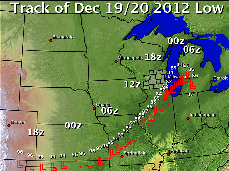
Below is a map of the actual track of the low pressure system Wednesday through Thursday. The small 2 digit numbers next the "L" is the pressure in millibars with the "9" missing. So, "82" would be 982 mb, which was the lowest pressure in the storm when it was crossing the Chicago area. The storm deepened 1 millibar per hour for 15 hours. Storms that strengthen 1 mb per hour or more for at least 24 hours are considered "explosive cyclogenesis", a technical term for rapidly deepening storms that are relatively rare. So, although this storm did not meet the criteria, it came rather close. The times are in UTC or Zulu, so 18z along the CO/KS border is Noon Wed, 00z over Kansas was 6 pm Wed, etc.
Below is a map of the actual track of the low pressure system Wednesday through Thursday. The small 2 digit numbers next the "L" is the pressure in millibars with the "9" missing. So, "82" would be 982 mb, which was the lowest pressure in the storm when it was crossing the Chicago area. The storm deepened 1 millibar per hour for 15 hours. Storms that strengthen 1 mb per hour or more for at least 24 hours are considered "explosive cyclogenesis", a technical term for rapidly deepening storms that are relatively rare. So, although this storm did not meet the criteria, it came rather close. The times are in UTC or Zulu, so 18z along the CO/KS border is Noon Wed, 00z over Kansas was 6 pm Wed, etc.
Below is a composite radar (made up of several NWS radar sites) animation of the storm as it moved through the region. The animation starts around 1 PM CST Wednesday afternoon, and ends around 8 PM CST Thursday evening. Note the color scale at the top of the image. The warmer the radar reflectivity returns indicate heavier precipitation. Note the high radar reflectivity returns Wednesday night into Thursday pivoting across south central and southeast Wisconsin. This lead to a prolonged period of moderate to heavy snow across south central and portions of southeast Wisconsin. Rain fell across far southeast Wisconsin Wednesday night into Thursday afternoon, before changing to snow late in the day.
CLICK HERE FOR IMAGE
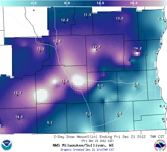
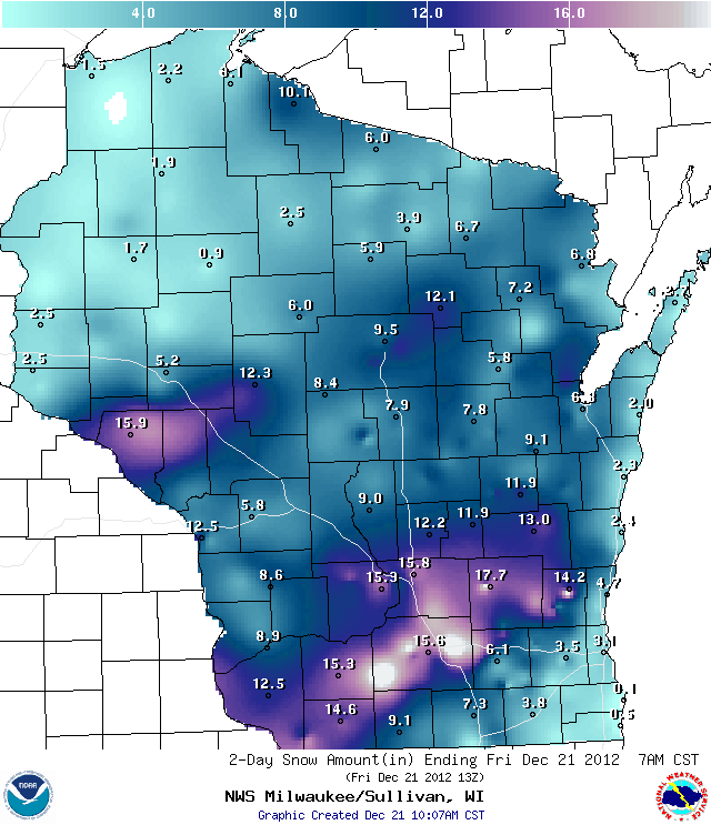
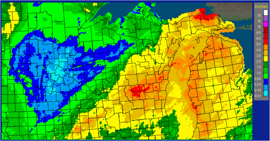
Snow totals: Snow totals ranged from less than an inch near Racine and Kenosha, to 12 to 20 inches in Dane County. Below are maps showing the snow accumulations across south central/southeast Wisconsin, and for all of Wisconsin, for the Dec 19-20th storm.
Impacts: Scattered power outages were reported. Drifting and falling snow made plowing activities difficult or almost impossible at times. Road surfaces were either snow covered and/or icy inland away from Lake Michigan. Hundreds of vehicle accidents were reported, and many vehicles became stuck in snow drifts. The Wisconsin DOT reported roads in Rock County were nearly impassable Thursday.
The snow and blowing likely caused some road closures in rural areas. Northwest winds gusted to 40 to 50 mph during the afternoon and early evening hours of Thursday. These strong winds, along with falling and/or blowing snow, resulted in blizzard or near blizzard conditions in open and exposed areas, with visibilities reduced to one quarter mile or less.
The snow and blowing likely caused some road closures in rural areas. Northwest winds gusted to 40 to 50 mph during the afternoon and early evening hours of Thursday. These strong winds, along with falling and/or blowing snow, resulted in blizzard or near blizzard conditions in open and exposed areas, with visibilities reduced to one quarter mile or less.

 RSS Feed
