--WINTER STORM WATCH FOR FAR SOUTHERN AND SOUTHWEST WISCONSIN THURSDAY THROUGH THURSDAY NIGHT...
-TONIGHT...PARTLY TO MOSTLY CLOUDY. ISOLATED FLURRIES FAR NORTHWEST. LOWS FROM THE MID TEENS NORTH...TO THE UPPER 20S SOUTH.
-THURSDAY...CLOUDY. SNOW SOUTH. CHANCE OF SNOW CENTRAL AND NORTH. ACCUMULATIONS OF UP TO FIVE INCHES FAR SOUTH. HIGHS FROM THE LOWER 30S NORTHWEST...TO THE MID AND UPPER 30S SOUTHEAST.
-THURSDAY NIGHT...CLOUDY. SNOW SOUTH. CHANCE OF SNOW ELSEWHERE. LOWS FROM THE UPPER TEENS FAR NORTH...TO THE UPPER 20S SOUTH.
Low pressure will move through the region Thursday and Thursday night, accompanied by a strong upper level disturbance. These features will bring the potential for heavy snow to portions of south central and southeast Wisconsin. There is somewhat higher confidence regarding the track of the low pressure system as it shifts through the region, and this will have a big effect on how much and where the heavier snow falls.
This track would allow the southern half of counties in south central and southeast Wisconsin, as well as Sauk County, to see the best chances for heavy snowfall. Given this low track, and the potential for heavy snowfall, a Winter Storm Watch remains in effect for this area. The rest of the counties in south central and southeast Wisconsin, to the north of the watch area, will see lower snowfall amounts. Thus, the Winter Storm Watch has been cancelled for this area.
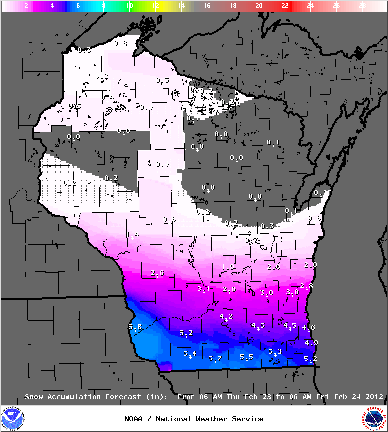
The snow should begin in the far western counties around 8 AM Thursday, reaching Madison by 10 AM, and Milwaukee between 11 AM and Noon. The snow is expected to continue through the day Thursday and through Thursday night. There are indications that weak instability aloft will bring the possibility of thundersnow, which would greatly enhance snowfall amounts in localized areas. This would be most likely across the Winter Storm Watch area.
See the graphic below for the expected snowfall amounts Thursday and Thursday night across the state
-TONIGHT...PARTLY TO MOSTLY CLOUDY. ISOLATED FLURRIES FAR NORTHWEST. LOWS FROM THE MID TEENS NORTH...TO THE UPPER 20S SOUTH.
-THURSDAY...CLOUDY. SNOW SOUTH. CHANCE OF SNOW CENTRAL AND NORTH. ACCUMULATIONS OF UP TO FIVE INCHES FAR SOUTH. HIGHS FROM THE LOWER 30S NORTHWEST...TO THE MID AND UPPER 30S SOUTHEAST.
-THURSDAY NIGHT...CLOUDY. SNOW SOUTH. CHANCE OF SNOW ELSEWHERE. LOWS FROM THE UPPER TEENS FAR NORTH...TO THE UPPER 20S SOUTH.
Low pressure will move through the region Thursday and Thursday night, accompanied by a strong upper level disturbance. These features will bring the potential for heavy snow to portions of south central and southeast Wisconsin. There is somewhat higher confidence regarding the track of the low pressure system as it shifts through the region, and this will have a big effect on how much and where the heavier snow falls.
This track would allow the southern half of counties in south central and southeast Wisconsin, as well as Sauk County, to see the best chances for heavy snowfall. Given this low track, and the potential for heavy snowfall, a Winter Storm Watch remains in effect for this area. The rest of the counties in south central and southeast Wisconsin, to the north of the watch area, will see lower snowfall amounts. Thus, the Winter Storm Watch has been cancelled for this area.
The snow should begin in the far western counties around 8 AM Thursday, reaching Madison by 10 AM, and Milwaukee between 11 AM and Noon. The snow is expected to continue through the day Thursday and through Thursday night. There are indications that weak instability aloft will bring the possibility of thundersnow, which would greatly enhance snowfall amounts in localized areas. This would be most likely across the Winter Storm Watch area.
See the graphic below for the expected snowfall amounts Thursday and Thursday night across the state
 RSS Feed
